Via Dinarica – Pro hikery

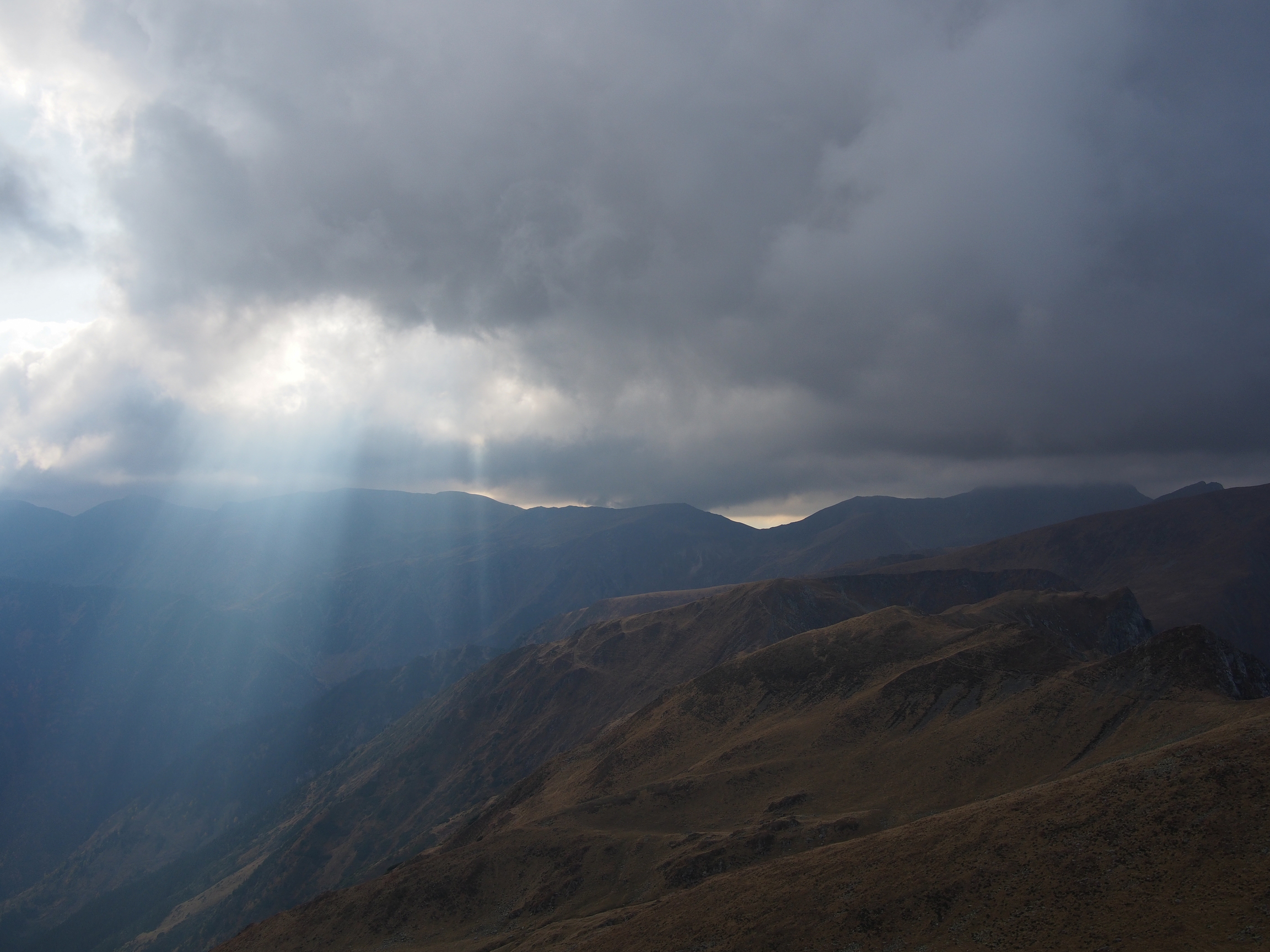
Od konce července do poloviny září jsem prošel Via Dinaricu ve Slovinsku, Chorvatsku a Bosně a Herzegovině. V tomhle příspěvku bych rád popsal pár zkušeností pro ty, kteří maj něco podobnýho v plánu a nebo je zajímaj praktický věci z tohohle dálkovýho přechodu.

Vybavení

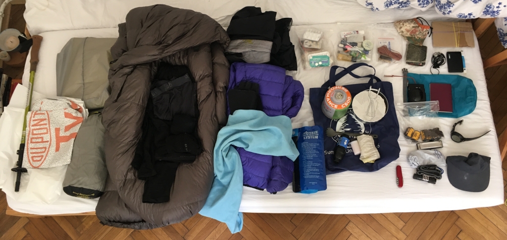
Můj batoh, bez jídla, vody a plynu na vaření, měl 5 kilo (konečná váha po pár úpravách po cestě). Tady je přibližný seznam všeho vybavení.

Bylo pár věcí, které jsem změnil po cestě a nebo bych nejspíš změnil do příště:

  • Tarp (jednostěnný stan bez podlážky) mám už delší dobu ale na týhle cestě mi nějakou dobu trvalo než jsem se cítil komfortně. Párkrát ve Slovinsku a na severu Chorvatska jsem chtěl moskytiéru a nebo uplně uzavřenej lehkej stan. Přecijen to přidá i k pocitu soukromí a izolace od okolí a to bych na začátku cesty ocenil, časem mi to začalo bejt jedno a komáři naštěstí zmizeli.
  • Hodně jsem přecenil reálnou spotřebu vařiče, nesl jsem velkou bombu (440g plynu) co jsem měl doma po ruce. Ta mi vydržela na celejch tisíc km, ještě v ní zbyl plyn a to jsem v jednu chvíli trochu dokonce upustil. Lepší by bylo si vzít malou kartuši, ve Splitu koupit novou a nosit míň váhy. Další nápad: covid desinfekce by se možná dala použít jako náplň do lihovýho vařiče. Líh v dostatečný koncentraci se tu jinak nikde neprodával, ale tohle by mohla být šance jak ještě odlehčit celý vaření.
  • Moje, rok stará, goretexová bunda značky Montane prostě a jednoduše nefungovala. Měl jsem s ní už smíšený zkušenosti před tím, ale teď i během krátkého lijáku protekla na několika místech i po tom co jsem jí po cestě znovu naimpregnoval. To beru jako vadu produktu, nepršelo mi nijak moc a bylo celkem teplo, takže to nebyl velikej problém.
  • Začínal jsem s lehkou péřovou bundou kterou jsem poslal domu protože bylo opravdu teplo. A nepostrádal jsem jí ani v Září v Bosně když už byla větší zima ( v noci i pod 5°C)
  • Taky jsem měl analogovej foťák Olympus XA, kterýmu začali bohužel blbnout časy a navíc jsem zjistil, že nejsem v náladě nějak víc se věnovat fotografii a dokumentace na iphone mi bude stačit.

Taky bylo pár věcí, se kterejma jsem byl extra spokojenej:

  • Quilt (moderní lehoučká verze dekového spacáku) místo normálního spacáku už nosím celkem dlouho a tady se zase osvědčil. Neměl jsem noc, kdy by mi bylo nepříjemně. Tři noci mi přišlo, že je příliš teplej ale vyspal jsem se v pohodě.
  • Baťoh se mi taky dál osvědčil, je uplně jednoduchej, ale nic mi nechybělo. Plastovej pytel co se dává do tzv “trash compactorů” od kamaráda z ameriky jsem měl vevnitř a v něm věci co musí být 100% suchý, to zafungovalo výborně. Když pršelo vytáhl jsem si bundu a šel v dál s jistotou že se večer vyspim v suchu.
  • Základní oblečení: Merino trička Icebreaker, fleecová mikina Rab, boty Altra a běžecký trenky mě udržovali v pohodě i když jsem byl spocenej, zmoklej a nebo byla zima, nic bych neměnil. Dlouhý kalhoty jsem vůbec neměl. Poznámka k botám: po asi 600km jsem hlavně na asfaltu cejtil, že jsou celkem sešlapaný a po 900km jsem měl už slušný díry co jsem musel lepit. To neni chyba bot, ale příště bych si koupil nový už někde po cestě i za cenu toho že tyhle to nakonec vydrželi.

Na tomhle výletě jsem si uvědomil, že udržování lehkýho baťohu záleží hodně na tom jak máte naplánovanou vodu a jídlo. Vybavení jsem sice akorát pět kilo, ale když přidáte jídlo na pět dní (=5kg) a k tomu vodu na celej den (=4kg) tak najednou máte 13kg což mi přišlo nekomfortní i po měsíci na cestě. Plánování se komplikovalo dvěma věcma:

  • Některý vodní zdroje byly suchý protože jsem šel celkem pozdě v létě. Obecně je to suchý krasový pohoří a občas je celkem horko, to platí dvojnásob od začátku Velebitu na jih Chorvatska
  • Malej obchod byl často i na místech, kde jsem o něm předem nevěděl, takže jsem mohl na některý sekce nést míň jídla. Taky místní pohostinnost a občasný restaurace a chaty je něco s čim by se dalo víc pracovat.

Navigace, denní kilometry a převíšení

Trvalo mi to 54 dnů na cestě, z toho jsem byl 17 dnů mimo trail. 11 dnů padlo na jednu šestidenní chřipku, občasný odpočinkový dny s bolavym kolenem a jednu krátkou otravu jídlem. Dva dny na covid test ve Splitu a zbývající čtyři dny jsem si dal prostě pohodu. Z výpočtů z map mi to vychází na celkem 965km, průměr na chodící den: 26km/den, celkově 18km/den. Nejkratší den jsem ušel asi 10km a nejdelší den 47km. Celkově jsem nastoupal 39 výškových kilometrů, tj v průměru 1000m každej den na cestě. Tempo jsem ale hodně změnil v čase, problémy s kolenama se objevili hned na začátku a tak jsem první skoro měsíc musel brát zlehka. Často jsem nebyl schopen jít celej den a končil jsem dřív odpoledne. To se pak změnilo a přišli delší dny, víc kilometrů a větší převíšení. V Bosně jsem se pak už cejtil, že po těch horách na pohodu běhám 🙂

Měl jsem vytištěný mapy z oficiální stránky Via Dinaricy na Outdoor Active, ty se mi hodily na plánování trasy, jídla, vody a jako záloha pokud by se mi něco stalo s telefonem. Taky jsem na ně pak psal deník co jsem po kouskách posílal domu v dopisech. Navigace podle nich by ale byla fakt veliká nouzovka. Na plánování jsem pak taky používal komentáře ostatních hikerů z minulejch let (taky na OA). Používal jsem občas navíc body co uložil SuperHip na svym blogu, tam jsou nějaký vodní zdroje navíc a pár dalších fajn míst a upozornění. Ty jsem pro změnu otevíral v aplikaci Open GPX Tracker.

Hlavní navigace byl můj telefon,používal jsem aplikaci WikiLoc, kde jsem měl jednotlivý sekce importovaný z gpx souborů stažených taky z oficiální stránky na Outdoor Active. Podkladová offline mapa byla dost špatná, ale bylo to rychlý, nepotřebovalo to moc baterky a tim pádem pro rychlou orientaci dostačující. Pak jsem používal Mapy.cz jako detailnější offline mapy na plánování alternativních cest, ty byly velmi přesný po většinu cesty. Bez gpsky tenhle trail podle mě nejde rozumě ujít protože na pár místech neni vidět žádná stezka a chybí značení. V hodinkách jsem měl kompas, kterej jsem použil jen asi dvakrát abych udržel směr.

Zdraví

Skoro dva týdny jsem nechodil, protože mi něco bylo. Utvořil/potvrdil jsem si z toho dvě hlavní osobní pozorování (bez nároku na medicínskou správnost):

  • Příchod do města je nejrizikovější čas na to, chytnout nějakou chřipčičku. Tělo je unavený a má pocit, že si to může dovolit, navíc vám přestane pracovat zažívání, tak jako funguje, když celej den šlapete. Snažil jsem se si pak dávat větší pozor: jít dřív spát, vypít vitamínovej šumák, dobře a zdravě se najíst, nevypít příliš studenýho piva a kafe i když to je přesně to co jsem vždycky nejvíc ve městě chtěl.
  • Problémy s kolenama jsou často až důsledkem slabejch svalů někde jinde a to hlavně těch, který jsou zodpovědný za stoupání a klesání. Já měl to štěstí, že můj kamarád mi dával na dálku konzultace a tak jsem rychle zjistil co je jádro problému a jak to řešit. Pro mě tvořily největší problém slabý hýžďový svaly, který se přetíží, stahujou váš “IT band” a vytváří bolest na vnější straně kolene. Řešení? Protahoval jsem ty stažený svaly a používal plnou láhev s vodou jako roller abych ty svaly a IT band pěkně rozválel. Pak jsem taky používal tape což fungovalo fakt dobře a podle mě mi zachránilo tenhle výlet. Problémům tohohle typu se dalo nejspíš předejít i trénovánim. Jsem sice aktivní člověk a na kratší výlety chodim často, ale v práci jsem seděl u počítače několik let a žádnej systematickej tréning na tohle dobrodružství jsem něměl.

Obecně mi přišlo důležitý se dobře poslouchat, dát si volno když jsem potřeboval, snažit se přijít na to, proč mě něco bolí a vyřešit to nejlíp ještě dřív, než mě to zastaví, nebo se to projeví někde jinde. Já ty svaly cejtil už od třetího dne, ale koleno mě začalo bolet až po deseti dnech, kdy jsem to neřešil. Jo a večer jsem jsem měl celkem fajn protahovací rutinu, z toho se stal takovej rituál — konec chození, začátek odpočinku :).

GPX body

Tady jsou body co jsem si uložil, hlavně prameny, hezký místa na kempování, použijte na vlastní nebezpečí.
Na Mapy.cz.
Jen body jako gpx.
Body a k tomu celá trasa VD.

Zvířata a miny

  • Plch je váš kamarád! Je to taková myšo-veverka, která rozhodně kandiduje na maskota Via Dinaricy, žije tu všude ve stromech, ale taky se ráda přijde podívat k vám do koliby, kde spíte. Leze po stěnách a dělá vám tam kravál. Nikdy se mi ale nestalo, že by vlezli do mýho jídla nebo věcí, jen jsem se párkrát hůř vyspal.
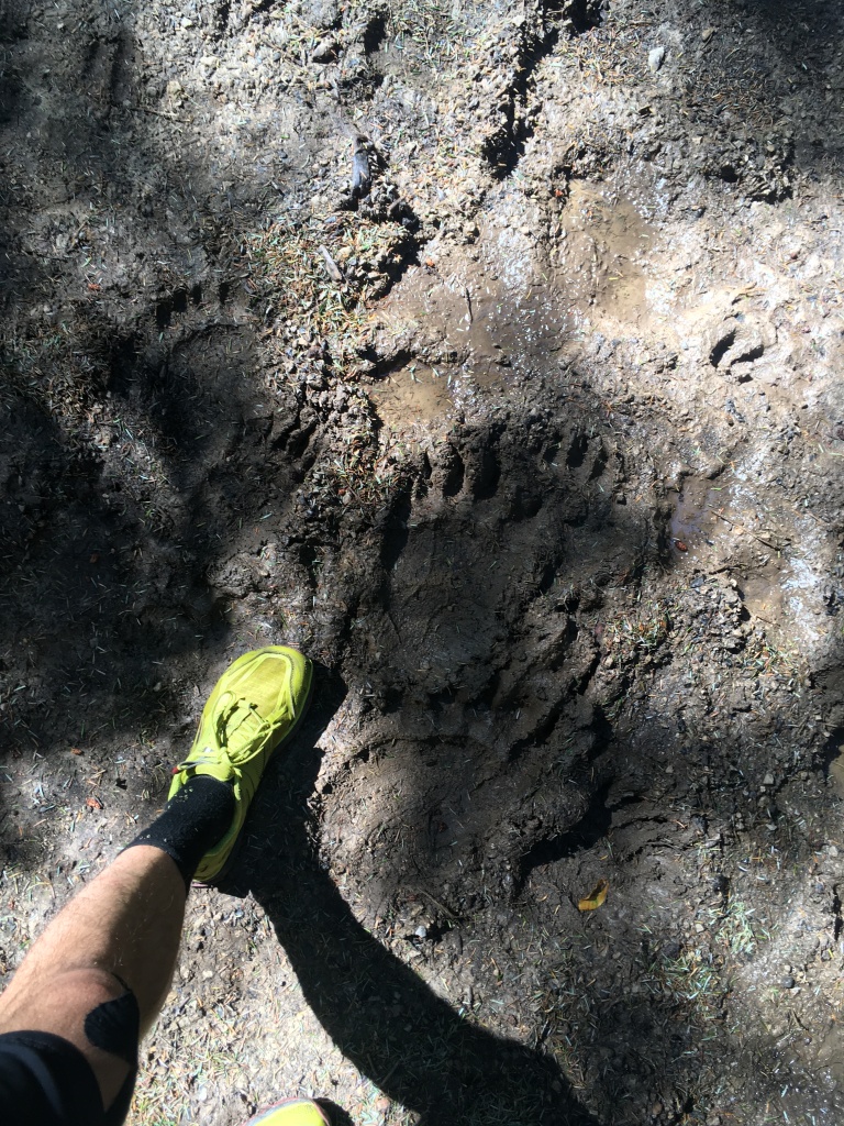
  • Slovinská část a sever Chorvatska má dost medvědů, byly tu vidět celkem často otisky a znám lidi, který tu medvěda viděli. Jídlo jsem nevěšel a obecně platí, že jsou to plachý zvířata, který se vám chtěj vyhnout. Statistika říká že poslední smrtelnej útok od medvěda byl ve Slovinsku naposledy asi před třiceti lety. Z místních a internetu jsem vytáhnul nějaký základní poučky co se můžou hodit. Špatný je medvěda překvapit, pokud jdete sami nepřehlednym terénem, je dobrý dělat trochu hluku navíc (hůlkama o kameny, občas si něco zazpívat). Pokud ho potkáte, pomalu se vraťte pozadu směrem odkud jste přišli, pokud je to máma a děti, hlavně nechcete stát mezi nima. Pokud na vás zaútočí prašťte ho do čumáku a pokud to nepomůže, lehněte si na zem břichem dolu a s rukama za hlavou a hrajte mrtvolu.
  • Od rezervace Bijele i Samarske Stjene na jih jsem měl info od místních a lidí co jsem potkal, že tu je dost zmijí. Žije tu i zmije růžkatá, to je nejvíc jedovatej had v Evropě a může být i na větvích stromů, kde čeká na ptáky. Kousnout vás nechce, ale je potřeba si dát bacha kam člověk šlape a taky pokud někam šahá rukama. Tahle kráska vás prý pozlobí tak, že vlastně jediný co vám zbude je zavolat horskou službu / záchranku, bejt v klidu a čekat.
Tohle bylo moje jediný setkání se zmijí růžkatou, bylo mi jí líto, ale bylo to bezpečné…
  • Občas potkáte pastevecký psi, hlavně v Bosně. Chrání většinou stáda nebo nějaký budovy a občas jdou celkem drsně do vás. Strategie: Vyhnout se stádu. Pozdravit farmáře, když tam jsou, pak občas toho psa odvolaj. Pohrozit psovi ať se klidí, nejlíp s kamenem v ruce, těch se bojí páč farmáři je používaj jako “výchovnej” mechanismus.
  • Miny: v národním parku Paklenica a pak skoro na celym území Bosny a Herzegoviny je potřeba si dávát pozor. Respektujte cedule, čtěte si detaily u jednotlivejch sekcí, kde jsou popsaný místa, kde je podezření na miny a ideálně se vždycky držte vyznačenýho/vychozenýho trailu (ne gpsky!!!). Třeba na dvou místech mi přišlo, že tam můžou být miny a bylo tam málo značek nebo stezka nebyla vůbec prochozená. Tam jsem se snažil jít super pomalu a najít kudy už někdo šel přede mnou nebo odhalit nějakou třeba vybledlou značku alespoň.

Migrace

Když jsem vyrážel, nepřemýšlel jsem nad tím, že celá trasa prochází země, kde dochází k migraci uprchlíků z jihu na sever. Uprostřed lesa ve Slovinsku mě kontrolovala hraniční stráž se samopalama kousek od hranice s Chorvatskem. Tam jsem zase slyšel od horalů, že převodníci používají koliby a vloupávají se do chat, když provádí uprchlíky horama. Jedna chata kvůli tomu byla zavřená a jednu kolibu jsem viděl plnou odpadků od jídla a kusů oblečení (kdo to byl nevím, ale takhle to popisovali místní). V Chorvatsku jsem měl dost pocit, že lidi jsou často vůči migrantům vysazení. Varovali mě, abych si dával pozor, nebo abych nechodil do Bosny, protože tam je migrantů mnohem víc, ptali se mě jestli jsem uprchlíky potkal, jakoby to byla nějaká velká hrozba, atd. Kromě té hraniční stráže jsem žádnou špatnou osobní zkušenost neměl, čechy tu navíc milujou. Jiný hikeři ale mluví o tom, že je vícekrát prohledávala policie (zdroj), nebo že se jich lidi báli, chtěli vidět pas, případně jim schválně nechtěli pomoct protože si mysleli že jsou uprchlíci (zdroj). Tohle bylo na trase citelné téma i když na mě nemělo výraznější praktický dopady.

Závěrem

Je to úžasnej zážitek a celkově bych řekl, že je to geniální spojení opravdu divoký přírody a poznání místních lidí a jejich života po cestě. Já mám pocit, že se do těch hor budu v budoucnu vracet a taky se už těšim na to, že si brzo projdu i sekce v Černý Hoře a Albánii, a možná i dál? Inspirace od Kuby tady.

Jsou asi věci, kterýma se tenhle trail liší od jiných dálkových tras s delší historií což ale nevim z osobní zkušenosti. To podle mě dělá tuhle trasu tak zajímavou, ale byly chvíle, kdy jsem si říkal, že to je nevýhoda:

  • Komunita: nejsou tu věci jako trail angelové, trail magic, obchody s vybavenim nebo nějaký speciální místa pro hikery. Vlastně tu ani nejsou moc ostatní horalové :D. I když tohle byl výjimečnej rok kvůli koroně, tak hikeři z minulejch let maj dost podobný zkušenosti, já jsem za celou dobu nepotkal jedinýho člověka, co by šel ven na dýl než na dva dny.
  • Civilizace a kultura: trasa prochází vlastně dost menších vesniček a ubytování a většina těch míst je celkem levná a dobře umístěná. Občas jsem si říkal, že je to super, protože jsem potkal místní lidi a vyspal se třeba i v posteli. A občas mi to vyšlo tak, že bych radši byl sám v divočině, ale zrovna jsem se večer někde vyloup a už byl unavenej, tak jsem si zaplatil ubytko. Tahle trasa byla postavená se záměrem podpořit udržitelný turismus v těch horskejch oblastech a dává určitě smysl tu nějaký ten peníz utratit, nikdo vás k tomu nutit nebude, ale ta trasa je tak prostě postavená.

Vyražte co nejdřív taky, hoře zdar!

Via Dinarica – For hikers

Since the end of July until mid September I hiked the Via Dinarica White Trail in Slovenia, Croatia and Bosnia and Herzegovina. In this post I want to describe some experiences for those who plan something similar, or just want to know some practical leanings from this long distance hike.

Gear

My base weight — pack without water, food, or gas — was 5 kg after a few small adjustments on the way. Here is an approximate gear-list.

There was a couple things that I have changed during the hike or that I’d like to change for the next time:

  • I have my tarp for two years already, but it still took me time to become comfortable on this hike. In Slovenia and the north of Croatia I wished I had an inner net tent or even a fully enclosed shelter. It would also add to the feeling of privacy and isolation from the environment, which I would appreciate at the start. Later on this stopped being a concern and mosquitoes disappeared.
  • I overestimated the gas consumption of my stove a lot. I carried a 440g gas cartridge which lasted for the whole hike and had still gas in it even though I let some out on purpose to make it lighter on the way. Better would be to start with less gas and buy a new canister in Split. Another idea was that the covid disinfection could be used as a fuel for an alcohol stove. Suitable alcohol is hard to find otherwise, but this could be a way to go even lighter.
  • My, one year old, goretex jacket from Montane simply failed. I had mixed experience with it before the hike and now it just leaked on multiple places after every short rain shower. Maybe that’s just a bad piece. Luckily I didn’t have much rain and it was quite warm, so no big issue for my hike.
  • I started with a light down jacket but sent it home because it was really warm. I didn’t miss it even later on in Bosnia which was a lot colder (less than 5°C in the night).
  • I also started with a film camera Olympus XA. The shutter times were not working properly and i realized I am not in the mood for photography and it will be enough to document my hike with my phone.

There were other things that I was especially satisfied with:

  • I carry a quilt instead of a normal sleeping bag for two years now and it has only proven itself again, there wasn’t a single night where I wouldn’t feel comfortable. Three nights were on the edge to being too warm, but I slept fine.
  • I was also happy with my pack again. It’s as simple as it gets but I didn’t miss anything. I use a trash compactor bag as a liner, which also worked great. When the rain started I just pulled my jacket out and hiked on knowing that I will sleep dry that night.
  • My base clothing: Icebreaker merino T-shirts, Rab fleece, Altra shoes and running shorts kept me happy when I was sweaty, cold or wet. I wouldn’t change anything. I didn’t carry any long pants. Note about the shoes: after around 600 km I felt the cushioning is not really working that well anymore, especially on hard surfaces like asphalt. At 900 km I had pretty large holes in both shoes that I had to tape. Not a failure of the shoe, I would just buy new ones earlier next time.

I realized on this trip that keeping your pack light depends a lot on how you plan water and food resupply. My pack was 5 kg but adding 5 days worth of food (=5 kg) and water for the whole day (=4 kg), you end up with 13 kg. That weight did not become comfortable even after a month of hiking. This was complicated by two factors:

1) Some water sources were dry because I went late in the summer and generally these karst mountains are very dry and it can get really hot, especially from the start of Velebit until the south of Croatia.

2) There were small shops that I didn’t know about in advance as they were not in my maps, I could have carried less food for some sections. Also, the local hospitality and occasional huts and restaurants is something you can work with.

Navigation, daily kilometers and altitude gains

It took me 54 days in total, from that 17 days I was off the trail. 11 days were spent for six days when I had a cold, some rest days for my knee problems and one time when I got food poisoning. Two days for a covid test in split and four days just to chill. From my maps I hiked 965 km in total, average for a hiking day 26 km and in total 18 km. Shortest day was around 10 km and longest was 47 km. I made 39 km of altitude gain, which is around 1000 m for each day hiking. However, my pace has changed a lot in time. Since the start I had some issues with my knees and so I had to take it light in the first month. After that there were much longer days and more altitude gains. In Bosnia I already felt like I am just running freely over the huge mountains :).

I had printed maps from the official page of Via Dinarica on Outdoor Active, those were useful for planning the route, food resupply, water and as a backup in case my phone dies. Using them for navigation would really be a big emergency though, they lacked a lot of detail. I further used those as paper to write my diary on, which I sent in batches back home by post. I also used the reviews of other hikers on OA page and POIs saved by SuperHip from his blog, he noted some extra water sources and other useful places. I used Open GPX Tracker app for this.

Main navigation tool was my phone, I used the WikiLoc app where I had imported all the sections from gpx files from the OA page. The offline map was really lacking detail but the app was fast and didn’t use much battery, so it was enough for basic orientation. Next to that I used Mapy.cz as a higher quality map, which was really precise for most of the way and I could plan alternative paths and have more detailed orientation. I don’t think this trail is doable without a GPS device since there are short parts with no trail or no markings. I also had a compass in my watch which I used twice to keep direction.

Health

I was off the trail for almost two weeks, because of my health. I have two main personal observations (with no claim of medical correctness):

  • The arrival to a town is the most risky time to catch some virus. The body is tired and feels like it can afford to get sick in the comfort of the city. Also the digestion works differently than if you walk the whole day. I tried to be careful: go to bed early, drink some vitamin drinks, eat well and healthy, do not drink too much cold beer or coffee even if that was the thing I craved the most.
  • Knee problems are often just the result of weak muscles somewhere else, mainly those that are responsible for going up or down hill.I was lucky to get remote consultations from my friend and we were able to find the issue and solutions quite fast. My problem was weak glutes, they get overloaded and start pulling too hard on the IT band which creates pain on the side of the knee. Solution? Stretch the muscles, use a plastic bottle filled with water as a roller to roll the muscles and the IT band properly. I also used tape, this was really effective and saved my trip in my opinion. The problem was probably preventable with proper training. I am an active person and go hiking quite often but still I had an office job for couple of years and didn’t have any systematic training for this hike.

If I can generalize, main thing seemed to be to listen to my body, take rest when I needed to, try to find out why something hurts and solve it. I felt my glutes after 3 days of hiking but only got knee pain after 10 days. I also had a stretching routine every night, it became almost a ritual — hiking is over and resting can begin :).

Useful POIs

Here you can find some points that I saved, water sources, nice campsites etc. Use at your own risk.

On Mapy.cz.
GPX files with points only.
GPX file with points and the VD route.

Animals and landmines

  • The Puh is your friend! It’s something between a squirrel and a mouse, which definitely runs for the mascot of the Via Dinarica. It lives everywhere in the trees and is active in the night. It likes to have a look into the hut that you are sleeping in, climb on the walls and make noise. It never happened to me that they would actually eat my food or go after my things, just slept bad on a couple of nights.
  • Slovenia and the north of Croatia has quite a big population of bear. I saw the footprints quite a few times and know people that saw bears here. I did not hang my food and generally the bear are smart in avoiding you. Apparently the last fatal attack in Slovenia happened around 30 years ago… Still, I got some basic learnings from the locals and the internet that might be useful. It is bad to surprise a bear, if you go alone in complex terrain it’s good to make a bit of extra noise, use trekking poles to hit stones or sing a little, for example. If you meet a bear, walk slowly backwards to where you came from, if it is a mother and cubs, be careful not to stand between them. If a bear already attacks you punch it in the nose, if it doesn’t help lay down on your belly with your hands on your neck and play dead.
  • From the Bijele i Samarske Stjene nature reserve to the south I was told by locals and hikers that there’s vipers. Main concern is the horned viper, which is the most venomous European snake. It lives around rocky sunny places, but you can find it in the grass and it can also be on the trees waiting for birds. It does not want to bite you, but its important to mind your step and watch when you are sitting down somewhere or reaching somewhere with your hands. When bitten I was told the only thing to do is calm down, call the ambulance or mountain rescue and wait.
My only encounter with the horned viper. Poor snake… but it definitely feels safe.
  • Sometimes you meet shepherds dogs, especially in Bosnia. They are usually protecting a herd of sheep or a house and sometimes they come after you. My strategy: avoid the herd. Say hi to the farmers, sometimes they call the dog off if they are around. Tell the dog confidently to go away, best with a stone in your hand, they really fear stones since the farmers use them as an “educational” method.
  • Landmines: in the Paklenica national park and almost everywhere in Bosnia and Herzegovina you have to be a bit careful. Respect signs, read the stage descriptions to know where suspected mine areas are, and stick to the marked/walked path if possible (not the GPS!). In about two places I felt like there could be mine risk and there was little marking and almost no trail. I went super slow and just tried to find a path where someone walked or where I could see at least some marking.

Migration

When I started, I did not think about the fact that these countries experience refugee migration from the south to the north. In the forest in Slovenia close to the Croatian border I was controlled by armed police. In Croatia I have heard from other mountaineers that smugglers break into huts and use refuges and shelters when they walk refugees through the mountains. One hut was closed because of that and one shelter was full of trash which is what the locals were associating with it. I felt like people in Croatia were often very much against refugees. I was warned to be careful, asked if I had met some or told not to go to Bosnia because there’s a lot more of them as if that was a big threat. Except for the police control I had no bad experience but other hikers reported being searched by the police (source) or that people were afraid of them, wanted to see their passport or refused to help them on purpose because they thought they are refugees (source). This is a significant and heavy topic on the route even if it had little practical impact on my hike.

Conclusion

It is an amazing experience and I would say that the route offers a perfect connection of wild nature and getting to know local people and their life. I will be returning to these mountains and I am looking forward to also finish the sections in Montenegro and Albania, and maybe beyond? Kosovo and Macedonia are worth it as well I’ve heard.

There are probably things where this trail differs from other, more established trails. That makes it so exciting, but I had a few moments when I thought that’s a disadvantage:

  • Community: there’s no trail angels, no trail magic, no shops with gear, no special hangouts for hikers. There’s actually almost no hikers :D. This was a special year with covid, but hikers in the past had similar experiences. I haven’t met a single person who would be out for more than two days.
  • Culture: the route passes quite a lot of small villages and accommodations which are often affordable and well located. Often this was great since I could meet the locals and even sleep in a bed! Sometimes I’d prefer to be out in the wild but in the evening I appeared somewhere and was tired so I paid for accommodation. The trail was build with the goal to promote sustainable tourism in the mountainous areas so it makes sense to spend some money here. You won’t be forced to do so, but it’s in the design of the route.

That’s it, now go out there asap, it’s wonderful!

Via Dinarica #6

For English please scroll down 👇🙏

Je zvlastni rano a z pokoje v Kalinovniku se mi nikam moc nechce. Civilizace mi vzdycky vezme trochu moji horalsky sily a nadseni, ale na poslednich par dnu se tesim a planuju si je jako pohodu, pujdu pekne pomalu, klidne zakempuju driv a bude to super. V tomhle duchu se vydavam na cestu. Kocham se prirodou, davam si obed na prvnim vrcholu, svacinu a koupacku u jezera v asi 1700mnm a po treti dojdu, kam jsem chtel.

Neco mi ale rika, ze mam jit dal. U chaty tu potkavam rangera narodniho parku Sjuteska, poznava, ze jdu Via Dinaricu a dodava, ze cesi jsou opravdu dobry horalove ☺️. Rikam mu, kam bych chtel dneska dojit a ocekavam klasickou odpoved zamestnance parku: uz je pozde a mam radsi zustat pac to je mnohem bezpecnejsi. Chyba! Typek rika “no jasne, bez, jsi fit ne? To das za 3.5 hodiny” — tohle byl jedinej casovej odhad mistnich za celou dobu, kterej vysel skoro uplne presne! Nabitej touhle podporou si tu nasledujici sekci hrozne uziju, kopce dolu sbiham a cejtim se fakt svobodnej. Kdyz zapada slunce stavim si stan u jezera Gornje Bare. Tohle byl skvelej den a navic vim, ze na tomhle miste to bude asi posledni noc, kdy jsem uplne sam v divocine a bez signalu tak si to radne vychutnavam.

Rano lepim obri diry v obou botach a doufam, ze na tech poslednich 40km jeste vydrzi. Klesam do kanonu reky Sjuteska a od ni uz pod muj cil, horu Maglic. Cesta vede castecne po hrane jednoho z poslednich evropskych pralesu Peručica, coz je opravdu zazitek a kdyby tyhle obri stromy zacali mluvit asi by me to zas tak neprekvapilo. Z tohohle zamysleni se pak vynorim primo pod horou, wow! Vypada fakt mocne. Chvili premejslim jit uz dneska na vrchol a k tomu jeste tezsi a primejsi cestou zapadni stenou. V tu chvili se ale moc fit necejtim a tak nakonec volim frekventovanejsi cestu pres Trnovacko jezero a rozhoduju se jit na vrchol az dalsi den rano. U jezera to celkem horalsky zije, je sobota a krasne. Davam si pivo a kafe a dalsi dve piva dostavam zadarmo od chatara, stavim si stan. Od pastevcu si tu kupuju chleba a kajmak (mistni specialita, neco mezi maslem a syrem) a je to pohoda.

Rano jsem svezi, stan nechavam u jezera a na vrchol si to dam rychlym tempem nalehko. A jsem tu… zmaknul jsem to?! Tisic kilometru krasnejma a divokejma balkanskejma horama. Velky emoce ale neprichazi, davam fotku, uzivam si, jak kolem me foukaj mraky a dekuju horam, ze me pustili tak daleko. Pak uz bezim dolu a na druhou snidani jsem zas u jezera, koupu se v krasne chladny vode a pak si davam ritualni oslavny kafe, rakiji a pivo. Zaver jsem si tezko dokazal predstavit lepsi!

V klidu balim, loucim se s mistnima a uplne bez namahy a trochu povznesene klesam dolu do doliny. Ted na me prijde celkem smutek, 54 dnu tyhle zabavy najednou konci. Pekne si to prozivam a za par hodin jsem uz dole na silnici. Tady potkam partu tri kamosu v aute co hledaj nejakej kratkej vejlet a tak se jim snazim poradit kam by mohli jet. Po tom, co se dozvedi, ze jsem zrovna usel asi 1000km jsou z toho hrozne nadseny, tak je beru jako takovou svoji osobni cilovou komisi 🥳. Nemaj pro me medaili, ale zato me odvezou kousek po silnici, kam potrebuju.

Pak uz jen cekam na autobus do Sarajeva a koukam u toho na horsky stity osviceny vecernim slunickem.

Hore zdar!

||

It’s a weird morning and I don’t really want to get out of my room in Kalinovnik. Towns always take a little bit of my mountaineering energy and enthusiasm away, but I’m looking forward to the last couple of days. I’m planning to have a chilled time, I’m going to go pretty slowly, camp sooner and it will all be great. With this in mind I start walking again. I am enjoying the views, have lunch at the first summit, a snack and a swim at the lake at about 1700m above sea level, and reach the place I wanted just after 3 O’clock. But something tells me I should go further. At the mountain hut I meet a ranger of the Sjuteska National Park, he recognises that I am hiking the Via Dinarica and adds that the Czechs are really good mountaineers ☺️. I tell him where I would like to go today and I expect the classic response of a park employee: “it is too late and you should stay because it is much safer”. My bad! The guy says “oh sure, go!, you’re fit right? You will make it in 3.5 hours” — this was the only time estimate of the locals, during the whole time, which was spot on! Charged with his support, I really enjoy the next section, I run down the hills and I feel really free. I pitch my tent at Lake Gornje Bare during sunset. This was a great day and I also realize that it will probably be the last night completely alone in the wilderness and without mobile reception, so I properly enjoy it.

In the morning I glue several giant holes in both shoes and I hope that they will still endure the last 40 km. I descend into the canyon of the Sjuteska river and from there already ascend under the Maglic summit, my final goal. The trail leads partly along the edge of one of the last European primeval forests Peručica, which is really an experience, if these giant trees started talking, I probably would not be too surprised. From there, I turn up right under the mountain, wow! It looks really powerful. For a while I think about going to the summit already today taking the harder route in the west wall. At that moment, however, I don’t feel very fit, so, in the end, I choose a more frequented way across Trnovacko Lake and I decide to go to the summit the next morning. The lake is quite busy with mountaineers, it’s Saturday and the weather is beautiful. I get a beer and coffee and then I get two more beers for free on the house. I pitch the tent and go buy some bread and kaymak from the farmers who herd sheep above the lake (local specialty, something between butter and cheese) all is great.

I feel fresh in the morning, I leave the tent by the lake and hike to the summit in a fast pace. And here I am … I made it?! One thousand kilometers of beautiful and wild Balkan mountains. But I have no big emotions. I take a photo, enjoy the clouds blowing around me and I thank the mountains that they let me go so far. Then I run down and I’m at the lake again just in time for second breakfast. I bathe in the beautiful cold water and then I have a ritual celebration with coffee, rakija and beer. I could hardly imagine a better finish!

I pack everything calmly, say goodbye to the locals and, completely effortlessly, start descending into the valley. Now I get quite sad, 54 days of this party just came to an end. I embrace all the emotions and in a few hours I’m down at the road. Here I meet a group of three friends in the car looking for a short trip and so I try to help them with where they could go. After they find out that I have just hiked 1000km, they are very excited about it, so I take them as my personal finish line committee. They don’t have a medal for me, but they take me down the road to where I need to go.

Then I’m just waiting for the bus to Sarajevo and watching the mountain peaks illuminated by the evening sun.

Goodbye!

Via Dinarica #5

For English please scroll down 👇

Tak jsem tu, v Kalinovniku, a davam si den pauzu. Poslednich deset dnu jsem prosel uz skoro celou cast Bosny a Herzegoviny a odslapal v kuse mozna nejvetsi prevyseni a kilometry v zivote. A byla to jizda, ktera se tezko popisuje. Zacnu tim nejhorsim:

Miny. Opravdu tu jsou a je to adrenalin pro horaly, jako jsem ja, ale hlavne bremeno pro tuhle zemi a trvala pripominka valky. Tohle tu na me obcas docela dopadlo, spis jako takovej smutek nez primy ohrozeni.

Prakticky to znamena chozeni jen po znacenych stezkach, zvlast tam, kde je primo podezreni na minova pole, cesty a okoli jsou totiz vycistene. To se obcas stava vetsi vyzvou nez si clovek mysli. Znaceni byva nekdy dost ridke a stezky prakticky neprochozene, drzet se jich vyzaduje stoparskeho umu! Nejlepsi situace pak je, kdyz mapy a oficialni gps trasa ukazuji jinou cestu nez je ta, co vypada, ze je snad znacena 🤗.

Tohle je podle me pozustatek odminovani|| I think these are traces of an extracted land mine.

Trasa ale dal stupnovala horskou krasu a tak clovek na trable s minama lehko zapomnel.

A hlavne jsem si v tehle casti dost uzival mistni pohostinosti, trasa totiz vychazela tak, ze jsem si dopral nekolikrat spanek v posteli, pivo, kafe, jidlo, rakiji a pokec s mistnima. A celkove jsem si vychutnaval vsechny pekny momenty.

A nakonec: me uz se blizi konec 😮! Via Dinarica jde oficialne ze Slovinska na sever Albanie (i kdyz je skoda zapominat na to, ze tenhle projekt se rozsiruje na dalsi zeme a treba Jakub to letos dosel az do Makedonie!). Kdyz jsem zacinal, s koronou bylo vsechno dost nejisty, rikal jsem si, ze vyrazim a uvidim, kam me to pusti. Taky jsem dobre nevedel, o cem to bude, nikdy jsem nesel sam na takhle dlouho. A ted jsem tu, po vic nez 900km v nohach. Abych ale mohl dojit poslednich 280km od hranic Bosny az do Albanie, potreboval bych dalsi test, kvuli kteremu bych ted musel na kliniku do Sarajeva a pak zpet k hranici. A ja se rozhoduju, ze to uz delat nechci, misto toho si uziju nasledujici dny na treku a tohle dobrodruzstvi pro tenhle rok ukoncim na nejvyssi hore Bosny a Herzegoviny, ktera se jmenuje Maglic a je primo na hranicich.

Mam smisene pocity, na chozeni a horskou krasu i utrapy s tim spojene jsem si navyknul az skoro na uroven zavislosti a predstava toho, ze to mam za par dnu “hotove” a mel bych slavit, je mi dost vzdalena. Vim ale, ze se sem do hor budu vracet a ze podobnejch cest bude v budoucnu vic. Tim pretvarim blizici se konec v novej zacatek a uzivam si kafe v hotelu Moskva v tyhle zapomenuty vesnici. Opravdu tu maj velkou fotku Putina nad recepci.

Drzte mi palce na ty posledni kroky.

||

So here I am, in Kalinovnik, taking a day off. In the last ten days, I have hiked almost the entire part of Bosnia and Herzegovina and covered perhaps the longest distance with the biggest elevation gain in one push in my life. It was a ride that is hard to describe. I’ll start with the worst:

Land mines. They really are here… it’s a bit of an adrenaline rush for mountaineers like me, but mainly a burden for this country and a constant reminder of the war. This has gotten to me quite a bit at times here, rather as a sadness than as an immediate danger.

In practice, this means hiking only on marked paths, especially where there are suspected areas, because those have been cleared. This is sometimes more challenging than one thinks. Markings are quite sparse at times and the trails can be practically invisible, this requires some good path finding skills! The best situation is when the maps and the official gps route show a different path than the one that seems to be marked 🤗.

However, the route continued to be even more captivating with interesting scenery, that it was quite easy to forget about the trouble with mines. And most of all, I really enjoyed the local hospitality in these days. The route allowed me to enjoy quite a few nights in a bed, beers, coffees, food, rakija (local brandy) and good chat with the locals. And overall I enjoyed all the nice moments.

And finally: the end of my journey is approaching 😮! Via Dinarica is officially going from Slovenia to the north of Albania (although it is a shame to forget that this project is extended to other countries and Jakub, for example, has hiked all the way to Macedonia this year!). When I started, everything was uncertain because of covid, I thought I would start and see how far I can go. I also didn’t know what to expect, I’ve never hiked alone for so long. And now I’m here, after more than 900km on foot. But in order to hike the last 280 km from the borders of Bosnia to Albania, I would need another covid test, for which I would now have to go to the clinic in Sarajevo and then back to the border. And I am deciding that I don’t want to do it anymore, instead I am going to enjoy the next days on the trail and I will end this adventure for this year on the highest mountain in Bosnia and Herzegovina, which is called Maglic and is located right at the border.

I do have mixed feelings, I’m now used to everyday hiking, the mountain beauty and even the struggle associated with it. Almost as if I was addicted. And the idea that I’m “done” in a few days and it’s time to celebrate is quite distant to me. But I know that I will return to these mountains and there will be more similar adventures in the future. This transforms the upcoming ending into a new beginning as I am enjoying my coffee at the Moskva Hotel in this forgotten village. They really have a big photo of Putin above the reception.

Wish me luck for my last steps 🕺

Via Dinarica #4

Tenhle prispevek bude kratsi, i kdyz tahle cast byla mozna nejintenzivnejsi na zazitky. Musim si ale neco nechat na vypraveni prece, navic dneska me jeste ceka vyslapat asi 1800 vejskovejch metru 🙈, uff.

Z Kninu jsem vylezl na nejvyssi horu Chorvatska, Dinaru, byl to opravdu zazitek na kterej jsem vstaval ve ctyri rano a ten den jsem nakonec dosel az k jezeru, kde jsem se vykoupal a krasne vyspal pod sirakem. Byl to urcite nejdelsi den na ceste, slapal jsem bez prestani asi 14 hodin. Slo se mi ale fakt dobre, mel sem uz kratsi a mnohem narocnejsi dny.

Vrchol masivu Dinara || Summit of the Dinara mountain

Dalsi den jsem uz sel jen po asfaltu a potreboval se dostat do mesta Sinj a otamtud do Splitu. Tech poslednich par dnu jsem dost premyslel, jestli svoje dobrodruzstvi neukoncim tady. Mel jsem uz tolik intenzivnich zazitku, ze bych se mohl spokojene vratit a dlouho si je jeste v klidu vychutnavat. Jenze me laka Bosna a chci jeste nejakou dalsi vyzvu..

Tahle silnice je pro me symbolickej konec chorvatska || for me this road is the symbolic end of the Croatian part of the trail

No a tak prijedu do Splitu a hned bezim na kliniku se otestovat na covid, aby me pustili pres hranice. To se dost zkomplikuje, ve Splitu jsem nakonec tri dny a na klinice jeste celkem trikrat pac mi neposlali vysledky atd. Nevadi, celkem si uziju mesto, koupacky v mori, fancy kaficka a v hostelu potkam par fajn lidi. Uz mam ale pocit ze tu trochu smrdim a mesto si me namotava na prst.

Split

Vyrazim! Pomaham si autobusem na hranici, vsechno klape a ja uz si uzivam novou energii z novyho mista. Jde se mi fakt dobre, lidi co potkam me kazdej den zvou nahodne na kafe, hory jsou tu pocitove tak velky, ze se cejtim uplne bezvyznamne a trochu drze, ze si tu jako beham pres tyhle obry. Jo a dostavam prvni komplimenty za svoji chorvatstinu (moje verze zkomoleny cestiny co celkem fajn funguje), super!

Po trech a pul dnech sem v Jablanici, to je asi tretina moji cesty touhle krasnou zemi. Drzte mi palce na dalsi cestu ❤️!

||

This post will be a bit shorter, although this part was perhaps the richest with experiences. But I have to keep something for telling stories later and today I still have to climb about 1800 altitude meters, uff.

From Knin I hiked to the highest mountain in Croatia, Dinara, it was really an awesome experience for which I got up at four in the morning and that day I managed to reach a lake, where I could swim and sleep beautifully under the stars. It was definitely the longest day so far, I hiked non stop for about 14 hours. But I felt really good, I had shorter and much more demanding days before. The next day I walked only on asphalt and needed to get to the town of Sinj and from there to Split.

In the last few days, I’ve been thinking a lot about ending my adventures here. I already had so many intense experiences that I could return home satisfied and enjoy them in calmness for a long time. But I am really tempted by Bosnia and by another challenge… I arrive to Split and immediately go to the clinic to test myself for covid, so that I can cross the border. It gets quite complicated, I end up spending three days here and going three more times to the clinic because they didn’t send me the results etc. Never mind, I enjoy the city, swimming in the sea, drinking fancy coffees and I meet a couple of nice people in the hostel. But I already feel like I am stuck here a little and the city wants to pull me into its comfortable life.

I’m finally leaving! I take a bus to the border, everything is working out and I am already enjoying the new energy from the new place. I’m feeling really well, the people I meet here invite me for coffee every day, the mountains are so big here that I feel completely insignificant and a little cheeky, for just running over these giants. I also receive the first compliments for my Croatian (my own version of weird Czech that people can understand), great! After three and a half days I am in Jablanica, it is about a third of my way through this beautiful country. Keep your fingers crossed for my next steps ❤️!

Via Dinarica #3 — Velebit

For English, scroll down 👇

Prave jsem ve meste Knin a davam oraz po prechodu pohori Velebit a pred pokracovanim na nejvyssi horu Chorvatska Dinaru. Tahle cast byl opravdovej zazitek, dobre se mi slo a priroda i vyhledy byly jeste lepsi nez jsem si predstavoval. Stezka se tu mota pres 200km v horach nad 1000mnm a pritom mate kazdy den nadherne vyhledy na more a vsemozne ostrovy a ostruvky, ktere se v nem vznasi. To dava zvlastni pocit prostoru horam, ktere jinak nejsou nijak extra vysoke. Zaroven se tu hodne meni vegetace. Podle toho, jestli jste na primorske a nebo vnitrozemske strane chodite bud bukovym lesem se vzrostlymi stromy, a nebo takovou stredomorsky kerovitou, az poustni, krajinou, kde je vam odpoledne opravdu horko. Stezka je tu pekne opecovana a prochozena coz je oproti severu Chorvatska dost znatelny rozdil a navic je tu spoustu krasnych kolib, kde lze na noc slozit hlavu a nabrat si destovou vodu. Voda na velebitu totiz v jine forme v podstate neexistuje, dest se vsakuje okamzite do vapencoveho podlozi a proto nezbyva nez sbirat destovku ze strech a povrchu do betonovych nadrzi. Kdyz mate stesti je u takové studny i kbelik s provazem a vy si muzete “lahodnou” studenou destovku poradne vychutnat :).

Premuzicova stezka, po tom se jde jinou rychlosti|| the Premuzic trail let’s me go with some real speed
Koliba 21. stoleti || 21st century mountain refuge

Po ceste jsem potkal taky super lidi: fotografa co foti zvirata v divocine a ma dost historek o foceni hadu a medvedu, mezinarodni skupinku lidi na projektu v ramci Erasmus+, kteri se o me skvele postarali a dokonce me vzali autem na nakup na dalsi streku, par z Argentiny co cestuje uz tri roky po svete, dve dalsi horalsky druziny se kteryma byla velka sranda a hostily me vlastnim jidlem a nakonec majitele penzionu v Kninu, kteri me tu hosti a chorvatsko-cesky si povidame o zivote a o jugoslavsky valce ve ktery hral Knin dulezitou roli, ale o tom az nekdy priste..

Super lidi z projektu Erasmus+|| Lovely people from Erasmus+ project
Prekvapeni od horalu z družstva Ostrc Zlatar || Surprise from the mountaineering club Ostrc Zlatar

Me uz se ted blizi konec Chorvatska a mela by me cekat krasna sekce v Bosne a Hercegovine, to ale az potom co se ve Splitu otestuju na Covid a smirim se s tim, ze pri navratu do CR se budu muset otestovat zase znovu protoze vsechny nasledujici zeme jsou na cervenem seznamu. Drzte mi palce.

Dinara, tam vyrazim zitra ve 4 rano || Dinara, starting the hike at 4am tomorrow

||

I’m in the town of Knin after crossing the Velebit mountain range and before continuing to the highest mountain in Croatia, Dinara. This section was a real experience, I felt great while walking and the nature and views were even better than I imagined. The trail runs over 200 km in the mountains above 1000 m and every day you have beautiful views of the sea and all the islands and little islands that float in it. This gives a special feeling of space to the mountains, which are not extra high otherwise. The vegetation also changes in an interesting way. Depending on whether you are on the coastal or inland side, you walk either through a beech forest with tall trees, or through a mediterranean, almost desert-like landscape with smaller trees and bushes where the afternoons get really hot. The trail is nicely maintained and walked through, which is quite a noticeable difference compared to the north of Croatia, and there are also many beautiful huts, where you can stay for the night and get rainwater. The water at Velebit basically does not exist in any other form. The rain soaks into the limestone bed immediately and therefore all that remains is to collect rain water from the roofs and the surface into concrete tanks. If you are lucky, there is also a bucket with a rope at the well and you can enjoy this “delicious” cold water :).

Along the way, I also met great people, a wildlife photographer who had plenty of stories about photographing snakes and bears, an international group of people on a project under Erasmus +, who took great care of me and even took me by car to do grocery shopping for the next section , a couple from Argentina who has been traveling around the world for three years, two other mountain clubs who were cool and hosted me with their own food, and finally the owners of the guest house in Knin, with whom I talk Czech-Croatian about life and about the Yugoslav wars, for which Knin played an important role, but thats something for another post.

For me, the end of Croatia is quickly approaching and a beautiful section in Bosnia and Herzegovina lies ahead. However, I can only get there after I get tested negative on Covid in Split and I accept that when I return to the Czech Republic I will have to do a test again because all the upcoming countries are on the red list. Wish me luck 🙂

Via Dinarica #2

English bellow.

Dorazil jsem k mori do mesta Senj! Kvuli problemum s kolenem, ctyrem dnum hodne spatnyho pocasi a nahodnemu dobrovolnictvi pro horolezecky klub “Kapela Zagreb” jsem tu o par dnu pozdeji, nez jsem planoval, o to tu ale nejde (jde o to usporadat nejakou tu peknou akci!).

Prvni cast me vedla do udoli, kde vyvera reka Kupa v narodnim parku Risnjak (hned zjistuju, ze tu zije pry jeste vic medvedu nez ve Slovinsku 🤗). Zajimavosti je, ze reka se objevuje uplne najednou , uz jako hotovy tok. Na jednom miste je jezero a odtamtud z hloubky vic nez 180m tece hotova reka modro fialove barvy s velmi chutnou vodou, nad kterou se vznasi magicky opar. Hloubeji se zatim potapeci nedostali a tak si tahle krasova zalezitost drzi svoje tajemstvi.

Kupa

Dal pak chci pokracovat na vrchol velkeho Risnjaku, odpoledne je sice bourka, ale predpoved slibuje fajn pocasi, strazce parku me ale premlouva, ze uz je pozde, a ze kvuli pocasi to neni bezpecne. Moc tomu neverim, ale stejne me boli koleno, tak campuju pod horou v divnym campu. Dostavam buchtu a kafe a cesky vysvetluju ze buchty mame u nas taky, nikdo tomu ale neveri, pry je to typicky chorvatske. Druhy den sup na vrchol, kde poprve dobre vidim more kolem mesta Rijeka. Je to zazitek, hory a more u sebe je celozivotni touha. Pak klesam dolu pres dalsi krasnej kopec Tuhobic, kde jsou vyhledy jeste lepsi a zakoncuju to prvnim spankem pod sirakem. Pres noc se me snazi vysat asi 20 komaru, spanek stredni. Rano vyrazim brzo pln optimismu a radosti ze odchazim od komaru. Bohuzel po par hodinach stoupani se koleno zjorsuje tak, ze se rozhoduju pro dalsi pauzu.

Risnjak
More v dali || The sea at a distance
Tuhobic

O par destivych dnu pozdeji se ocitam v udoli pod rezervaci Bile a Samarske Steny. Zacina uplna krasa a teren, kde jdu, nebo spis lezu, asi 1km za hodinu. Predstavte si neco jako Ceskosaske Svycarsko vyrobene z vapence. Tohle by byl uplny raj pro lezce, to se tu ale nesmi a tak bile veze zustavaj nedotceny. K veceru se me ujme parta mistnich horalu z oddilu Kapela Zagreb, stavi tu svepomoci uplne novy pristresek (kolibu) pro turisty, bude nejvetsi v Chorvatsku s kapacitou asi 30mist na spani. Je tu i pan architekt, ktery je mimochodem autorem dalsich dvou kolib v pohori Velebit, ktere znam z fotek ostatnich hikeru. Popijem rakiji a pak me premluvi, ze mam jeste den zustat a pomoct betonovat zaklady pro terasu. Proc ne, druhy den 10h tvrde prace, dobrej pocit a super rozhovory s lidma, kteri jsou na stejne vlne.

Rano se vrele loucime a ja si davam za cil to dovalit az k mori. Vsechno stiham a mam stesti i na stop a kolem sedme uz se koupu. Koleno se asi lepsi a tak davam pohodu a zitra vyrazim do pohori Velebit, kde to ma byt super. Drzte mi palce, Franta.

||

I arrived at the sea in the town of Senj! Due to knee problems, four days of very bad weather and random volunteering for the mountaineering club “Kapela Zagreb”, I’m here a few days later than planned, but that doesn’t bother me. The first part led me to the valley into the Risnjak National Park where the river Kupa springs (I immediately found out that there are more bears living here than in Slovenia 🤗). The interesting thing is that the river appears completely at once, as a significant stream. In one place there is a lake and from there, from a depth of more than 180m, flows a river of blue-violet color with very tasty water and a layer of magical mist levitating above the surface. The divers haven’t gotten deeper yet, so this karst phenomenon still keeps its secrets. Further I want to continue to the top of the big Risnjak, in the afternoon there is a storm but the forecast promises good weather. In the end, the park ranger persuades me that it is too late to go up and that it is not safe due to the weather, I do not believe it, but since my knee hurts I decide to camp under the mountain in a strange camping place. The second day I reach the summit and, for the first time I get a view at the sea around the city of Rijeka. It is an experience, the combination of mountains and the sea is a lifelong desire of mine. I continue down over another beautiful peak called Tuhobic, where the views are even better and I end the day with the first night of cowboy camping. Overnight about 20 mosquitoes try to suck my blood, sleep bellow average. In the morning I leave early full of optimism and joy of leaving the mosquitos. Unfortunately, after a few hours of climbing, the knee worsens so that I decide to take another rest day. A few rainy days later I find myself in a valley below the Bjele and Samarske Stjene reservation. A beautiful wilderness starts and I slow down to 1km per hour because of the difficult terrain I hike (or rather climb) through. Imagine something like the Bohemian Switzerland made of limestone. This would be a complete paradise for climbers, but it’s not allowed here, so the white towers remain pristine. In the evening, a bunch of local mountaineers from the Kapela Zagreb club take care of me. They’re building a completely new public shelter (hut) for tourists. It will be the largest one in Croatia with a capacity of about 30 places to sleep. There is also the architect who is also the author of two other huts in the Velebit mountains, which I know from photos of other hikers. We drink rakija and they convince me to stay another day and help them concrete the foundations for the terrace. Why not, the second day I do some hard work, feel great and get into many interesting conversations with people of similar mindset. We say goodbye in the morning and I am determined to hike all the way to the sea. It all goes well and I’m even lucky with hitching a ride to the shore so I’m already bathing around seven O’clock. My knee is getting better, I am taking a day of rest and tomorrow I will start approaching the Velebit national park, where it should be great.

Wish me luck,
Frantisek

Via Dinarica #1

Eng bellow.

I pres nepriznivou korona situaci jsem se po dvou mesicnim odkladu rozhodl zkusit projit dlouho planovanej trek po hrebeni Dinarskych Alp. Trasa se jmenuje Via Dinarica a jeji hlavni cast aktualne vede ze Slovinska do Albanie, je dlouha asi 1200km a ma previseni okolo 50km. Zajemcum doporucuju si projit trasu tady, je to lahoda.

Dneska jsem devaty den na ceste a davam si jeden den voraz v Chorvatsku kousek od hranice narodniho parku Risnjak. Za sebou mam asi 180km stravenych hlavne v krasnych Slovinskych horskych hvozdech (takhle obri jedle a buky jsem jeste nikdy nevidel) a uz mam plno zazitku. Poprve v zivote jsem videl stopy medvedu mimo zoo— opravdu tu jsou, ale pokud se k nim chovate slusne, nic vam pry neudelaj. Potkal jsem velmi malo lidi, mistni do hor tolik nechodi a kdyz tak jen na turisticka mista, ale zato kdyz uz nekoho potkam tak mi chce pomoct a nebo je to nekdo podobne silenej jako ja :). Taky me na Schengensky hranici kontrolovala v lese tajna straz na uprchliky a na hranicnim prechodu me obdivovali chorvatsky vojaci. Par fotek a pokracovani priste (snad od more v Chorvatsku kde planuju dalsi voraz). Pokud chcete dalsi clanky mailem tak se prihlaste k odberu.

Prvni kopec || First hill 🤗
Prvni pivo || First beer 🕺
Mam vetsi nohu ale vic se bojim|| My foot is bigger but I am more scared

||

Against the unfavorable corona situation and after postponing the start by two months I have decided to attempt my hike along the Dinaric Alps. The trail is called Via Dinarica and currently spans from Slovenia to Albania, it’s around 1200km long with 50km of altitude gain. I suggest you check the map if interested, it’s beautiful.

Today I am the ninth day on the trail having a rest day close to the border of the Risnjak national park. I hiked around 180km mostly through beautiful Slovenian forests (I have never seen such tall oak and fir trees) and already have plenty of interesting experiences. I saw bear footprints for the first time outside of a zoo — they really exist, apparently if you treat them with respect they are not going to hurt you. I only met very few people, locals don’t go too much into the mountains or just go to see the main sights. But the people I meet always try to help me or are equally crazy as I am:). I also got controlled at the Schengen border by secret refugee patrol in the forest and admired by the Croatian military at the border crossing. Few photos and until next time, hopefully from the sea side in Croatia where I am planning my next rest stop. If you want the next updates via email, consider subscribing to the blog.